


PRECINCT VERNON B, Clinton County, Ohio
About
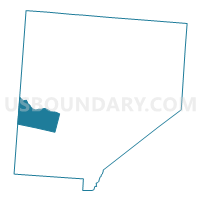
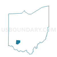
Outline

Summary
| Unique Area Identifier | 643658 |
| Name | PRECINCT VERNON B |
| County | Clinton County |
| State | Ohio |
| Area (square miles) | 14.51 |
| Land Area (square miles) | 14.37 |
| Water Area (square miles) | 0.13 |
| % of Land Area | 99.08 |
| % of Water Area | 0.92 |
| Latitude of the Internal Point | 39.36099060 |
| Longtitude of the Internal Point | -83.95137140 |
Maps

Graphs
Select a template below for downloading or customizing gragh for PRECINCT VERNON B, Clinton County, Ohio


Neighbors
Neighoring Voting District (by Name) Neighboring Voting District on the Map
- 0063 HAR-T-N Voting District, Warren County, OH
- 0078 WASH-T-N Voting District, Warren County, OH
- 0110 WASH-T-S Voting District, Warren County, OH
- 0172 HAR-T-NE Voting District, Warren County, OH
- PRECINCT CLARKSVILLE, Clinton County, OH
- PRECINCT MARION, Clinton County, OH
- PRECINCT VERNON A, Clinton County, OH
- PRECINCT WASHINGTON B, Clinton County, OH
Top 10 Neighboring County Subdivision (by Population) Neighboring County Subdivision on the Map
- Marion township, Clinton County, OH (5,394)
- Harlan township, Warren County, OH (4,698)
- Vernon township, Clinton County, OH (2,997)
- Washington township, Warren County, OH (2,717)
- Washington township, Clinton County, OH (2,130)
Top 10 Neighboring Place (by Population) Neighboring Place on the Map
Top 10 Neighboring Unified School District (by Population) Neighboring Unified School District on the Map
- Wilmington City School District, OH (20,781)
- Clinton-Massie Local School District, OH (9,904)
- Blanchester Local School District, OH (8,935)
Top 10 Neighboring State Legislative District Lower Chamber (by Population) Neighboring State Legislative District Lower Chamber on the Map
Top 10 Neighboring State Legislative District Upper Chamber (by Population) Neighboring State Legislative District Upper Chamber on the Map
Top 10 Neighboring 111th Congressional District (by Population) Neighboring 111th Congressional District on the Map
Top 10 Neighboring Census Tract (by Population) Neighboring Census Tract on the Map
- Census Tract 9649, Clinton County, OH (4,984)
- Census Tract 9648, Clinton County, OH (4,942)
- Census Tract 324, Warren County, OH (4,698)
- Census Tract 311, Warren County, OH (3,858)